December 11, 2025
Wondering why Lake Lanier’s shoreline looks different from month to month and what that means for your move? If you’re buying or selling on the lake, water levels influence dock usability, photos, and day-to-day access more than you might think. In this guide, you’ll learn how the lake is managed, what seasonal patterns to expect, and how to time photography and showings for the best outcome. Let’s dive in.
Lake Lanier is managed by the U.S. Army Corps of Engineers, Savannah District, through operations at Buford Dam. The Corps follows a Water Control Plan that balances flood risk reduction, water supply for the Atlanta region, hydropower, downstream flow obligations, and recreation. These priorities guide release decisions and target elevations throughout the year.
Lake level, or “stage,” is measured as elevation above mean sea level. Real-time and historical stage graphs are available from the Corps and state water-data services. The key takeaway is that Lake Lanier’s level is a managed variable. Operators adjust releases in response to rainfall, forecasts, storage needs, and regional agreements, so the lake does not behave like a natural tide.
Late winter through spring often brings higher inflows from storms, though the Corps may keep levels lower to preserve flood-storage capacity. By late spring and summer, recreation demand is high, but withdrawals for municipal use, higher evaporation, and dry periods can pull the lake down. Late summer into fall can see further drawdown during extended dry spells, while tropical systems can refill the lake quickly.
Routine seasonal swings tend to be moderate and are often predictable through Corps forecasts. The largest swings happen during droughts or unusually wet periods. Plan for variability and be prepared for occasional extremes that can change dock access and shoreline appearance.
Not all docks respond to water changes the same way. You’ll see two primary types around Lanier.
Boat lifts and boathouses require minimum water depth and clearance. If the lake falls below a lift’s rated depth, operations can be limited or unsafe. During high water, over-topped decking and submerged components increase wear and damage risks.
Permitting matters. Many docks require Corps or county permits, and private rights or lease arrangements vary by parcel. As a seller, gather permits and maintenance records. As a buyer, confirm the structure complies with current rules and ask for the most recent inspection.
Public and private ramps depend on ramp slope and current waterline. Extremely low stages can put some ramps out of service. Marinas may shift slip locations or adjust operations as levels change. If year-round boating is important to you, ask operators about historical low-water operations and the elevations at which access becomes limited.
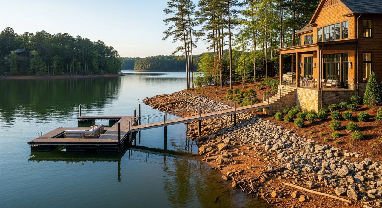
When the lake is low, mudflats, rocks, and vegetated zones can be exposed. That may affect how a property photographs and how buyers perceive it. Fluctuating waterlines can also accelerate shoreline erosion in some areas. Look for signs like slumping, exposed roots, or retreating vegetation. These conditions can impact maintenance planning and long-term aesthetics.
In some cases, low water can change groundwater conditions near shore. If a property relies on a lakeside septic or drainfield, consult county health authorities as part of your due diligence.
Depth changes alter where and when you can use certain coves and channels. Shallow coves may become inaccessible at low stages. Larger boats with deeper drafts feel the impact first. If you own or plan to own a larger vessel, verify typical water depths and seasonal access in your preferred area of the lake.
Fluctuating lake levels are not usually an insurable peril by themselves. However, high water events, erosion, and dock damage can influence coverage scope and premiums. From a valuation standpoint, reliable year-round access is a premium feature, while ongoing low-water limitations can affect marketability.
Some lenders may require evidence of legal dock access or flood-zone and shoreline disclosures. Be ready to share dock permits, compliance status, and any shoreline stabilization records during underwriting.
Steep gangways during low water increase fall risk. Submerged hazards can shift with high or low events and affect navigation. Disclose known hazards and past repairs. As a buyer, request an inspection that covers the dock, lift, anchoring, gangway slope at varying stages, and shoreline stability.
You want to set accurate expectations while showcasing the lifestyle.
Timing matters. If your goal is to maximize perceived access and lifestyle, schedule showings during typical recreational stages. If you list during a season when the lake is lower, be proactive. Share seasonal ranges, recent water trends, and historical behavior for your area of the lake.
During showings, walk the shoreline and dock. Demonstrate how the gangway functions at the current level and explain any adjustments you make as levels change. Have permits, maintenance records, and lift specifications on hand so buyers can make informed decisions.
Use this list to verify usability, compliance, and long-term value.
Documents and data
Property and infrastructure
Risks and negotiation
The key is to plan for normal seasonal shifts and be ready for occasional extremes. If you’re selling, gather permits, service records, and multi-season photos before you hit the market. If you’re buying, verify dock type, lift requirements, shoreline stability, and access across different stages. With clear data and the right timing for photos and showings, you can protect your value and avoid surprises.
If you want local guidance on timing, photography, dock due diligence, or how to position a lakefront home, reach out to Dani Burns. You’ll get straight answers and a plan tailored to your goals on Lake Lanier.
We believe exceptional homes deserve exceptional representation. From exclusive properties to seamless negotiations, we represent every client with the care, precision, and elevated service luxury real estate demands.